Introduction
Autonomous Underwater Vehicle (AUV) are widely used in detection and data gathering where Remotely Operated Vehicle (ROV) range is too limited. Historically, AUV are large and designed to be on board a vessel with a crew specifically trained for this purpose. Thanks to its size, these large AUV can make long mission (several dozen hours) in deep sea, up to 6000 meters ! However, for missions closer to shore, medium, large and very large AUV are complex to implement, costly and requiring many operators. In the recent years, miniaturization of the electronics unlocked the last bolt that was blocking the industry for smaller AUV : the navigation sensors. Nowadays, AUV market range is wide : from micro- AUV (20k€) to very large AUV (3M€) depending of the target missions.
The final cost of an AUV depends greatly on the payloads that the customer wishes to integrate into their drone, the quality of the navigation sensors (critical for an autonomous drone) and the level of industrialization of the vehicle. The largest AUVs are custom-designed according to the end user’s requirements. The underwater environment is very specific, comparable to the difficulty of space exploration robots, unlike the relative simplicity of modern aerial drones. For example, underwater robots communicate exclusively through acoustics. Electromagnetic (EM) waves are absorbed by water, and optical communications require a line of sight to be used. For comparison, the speed of EM waves in the air (used for aerial drones) is 300,000 km/s. The speed of underwater acoustic waves is 1,500 m/s. Another direct consequence is the absence of GNSS satellite positioning. In other words, it is impossible to control the AUV in real time or to position it ‘simply’. This article discusses the various positioning solutions that make autonomous navigation possible.
Positioning
For extended AUV operations, enhanced long-term positioning accuracy is essential to ensure the vehicle completes its journey to the destination and back to the launch site. The basis of industrial underwater navigation is dead reckoning, along with aiding sensors. In addition to this, there is another important source of external aiding for positioning: underwater acoustic positioning.

Dead reckoning positioning
Dead reckoning positioning for AUVs involves estimating the vehicle’s position by integrating its movements from a known starting point. The system continuously measures speed (from a sensor or from an estimation with the thruster), direction and elapsed time using sensors. This data is combined to calculate the current position. However, as no external reference is available underwater, measurement errors accumulate over time, leading to a gradual drift in the estimated position since no sensors are perfect.
The fundamental sensors for dead reckoning navigation are as follows:
• Pressure sensor, to estimate the depth of the AUV (and therefore, the “Z axis”).
• An inertial measurement unit (IMU) for orientation. An IMU consists of a gyroscope and an accelerometer. This sensor is crucial and historically the heaviest, most imposing and most expensive sensor of dead reckoning positioning. However, in recent years, thanks to the development of micro-electromechanical systems (MEMS) technology, IMUs have become small and inexpensive, but they have significant drift over time. Figure 2 shows the details of IMU technologies. For large AUVs, fiber optic gyroscope (FOG) technology is the most dominant.
• A simple GNSS antenna for initialization and ascent.
In addition to these, there are “aiding” sensors to improve positioning accuracy. These are not mandatory, but very useful :
• A magnetometer to assess the drone’s heading relative to true north. This sensor is mandatory when MEMS gyroscope is used for the IMU due to its drift over time.
• A dual GNSS antenna to recalibrate the drone’s heading at each ascent. To be the most accurate as possible, the distance between the two antenna must be at least at 70 centimeters.
• A Doppler Velocity Log (DVL) to obtain two information that are crucial for an AUV: the robot’s altitude relative to the ground, and the robot’s linear speeds relative to the ground. Without it, it is not possible to do altitude based navigation which is important for sonar scanning. Furthermore, the lack of DVL strongly impact the positioning accuracy, as there is no other way to estimate and compensate the water current. It’s as if someone were pushing you while your eyes were closed; you have no idea how far you’ve moved in space.
Underwater acoustic positioning
As stated in the dead reckoning section, the lack of external reference while the AUV is moving underwater imply gradual drift in the estimated position. For long missions, especially very long missions of dozen of hours the underwater acoustic positioning can be game changing. It is an addition while the dead reckoning positioning is still used as a reference. For micro-AUV where underwater acoustic positioning deployment can be a constraint, as opposed to the micro-AUV’s ‘one man portable’ principle, this is usually preferable to do more ascent during a mission.
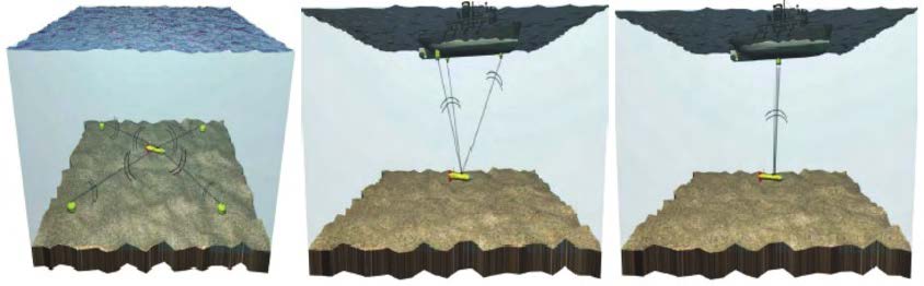
There are three big acoustic positioning methods :
• Long BaseLine (LBL) / GNSS Intelligent Buoys (GIB)
The principle behind LBL and GIB is the same. The difference is that LBL beacons are anchored to the seabed, while GIB beacons are floating. In both cases, the location of the beacons must be as accurate as possible. By measuring the propagation time of acoustic signals between the vehicle and several beacons, it is then possible to determine the position of the AUV by triangulation. This type of positioning offers high accuracy, but requires good calibration and a configuration adapted to the mission area. LBL can be subject to acoustic masking due to the terrain. Is possible to still aid the positioning algorithm of the AUV with only one, or two beacons but the accuracy is greatly impacted. However, even only one beacon offer real time communication with the AUV which can be useful.
• Ultra Short BaseLine (USBL)
The USBL system operates using a compact array of transducers placed close together at a known distance, usually mounted on a surface vessel or a fixed structure. By measuring the differences in phase and travel time of the acoustic signals between the transducers and the AUV, the system can determine the vehicle’s position relative to the array. USBL
provides real-time tracking without the need for multiple external beacons. However, its accuracy decreases with distance and can be affected by acoustic noise, multipath propagation, or vessel motion.
• Short BaseLine (SBL)
The SBL system follows a similar principle but uses several transducers spaced farther apart, typically installed on the hull of a ship or on fixed platforms. The larger spacing allows for improved geometric accuracy compared to USBL, especially at greater depths. As with USBL, the position of the AUV is derived from the travel times of the acoustic signals. While SBL offers higher precision, it requires a more complex setup and careful calibration of the transducer positions.
Data fusion : Estimators
To obtain a reliable and accurate position over time, all the data from the various sensors mentioned above must be combined. This process is called data fusion. Each sensor has its own characteristics, advantages, and limitations: for example, the IMU provides fast and continuous information but drifts over time, while the DVL or acoustic positioning
systems provide more accurate measurements but at a lower frequency or only intermittently. Each sensor also has different degrees of incertitude in its measurements. The goal of data fusion is to make the best possible use of each source of information and incertitude. To achieve this, estimators are used. The most common and widely used in AUV navigation is the Kalman filter, or more precisely, its nonlinear variant, the Extended Kalman Filter (EKF). This algorithm continuously estimates the AUV’s state (position, speed, and orientation) by predicting it from the previous state and correcting it whenever new sensor measurements are available. In simple terms, the estimator “trusts” the IMU for short-term motion, but regularly corrects its estimation when other sensors such as the DVL, magnetometer, or acoustic positioning provide new data. The quality of the navigation solution depends largely on the estimator’s tuning and the quality of the sensor models used. More advanced approaches, such as the Unscented Kalman Filter (UKF) or Particle Filters, can be implemented for complex missions or when nonlinearities are too strong. However, the Particle Filters requires lot more computation capacities.
From positioning to navigation : Plannification and
guidance
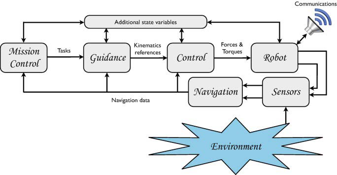
Once reliable positioning is achieved, the next step is to achieve true autonomous navigation. Navigation in this context includes three key components: planning, guidance, and control. Planning (or Mission Control) defines the trajectory or mission that the AUV must follow. This can range from simple waypoint following to more advanced path optimization based on mission objectives, terrain constraints, or energy consumption. Guidance ensures that the AUV follows this planned path by continuously comparing the desired trajectory with its actual position and orientation. Control acts directly on the AUV’s actuators (thrusters, fins, etc.) to correct its movement in real time. In practice, the positioning and estimation system provides the necessary data for guidance and control. The quality of navigation therefore depends on the entire chain — from the sensors and estimator, up to the guidance and control algorithms. For most missions, especially in coastal or cluttered environments, robust navigation algorithms are required to handle disturbances such as water currents, limited bathymetry visibility, or acoustic range. Modern AUVs often integrate mission management software capable of dynamically re-planning routes or returning to a safe point if navigation uncertainty becomes too high.